Trail Walking Le Broc - Le BROC, Sommet et Le PELOUA - Photo
 ch2slv
ch2slv

User

© OpenStreetMap contributors
Length
Length
11.4 km
Max alt
Max alt
892 m
Uphill gradient
Uphill gradient
483 m
Km-Effort
Km-Effort  
17.8 km
Min alt
Min alt
444 m
Downhill gradient
Downhill gradient
494 m
Boucle
Boucle
Yes
Creation date :
2015-12-13 00:00:00.0
Updated on :
2015-12-13 00:00:00.0

(0 Reviews)

Walking
Walking
3h53
Difficulty : Easy

Scan this QR Code to open this trail in the SityTrail application

FREE GPS app for hiking

Logo SityTrail SityTrail

IGN / Geographical institutes

Download SityTrail from the App Store Download SityTrail from Google Play

Logo SityTrail SityTrail World

The world is yours!

Download SityTrail from the App Store Download SityTrail from Google Play Download SityTrail on Huawei AppGallery

About

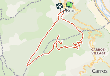
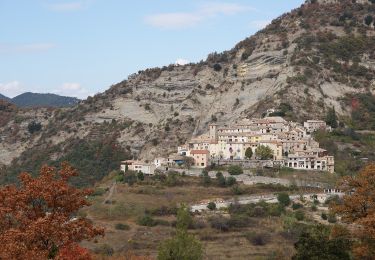
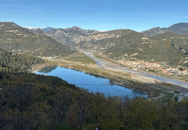
Trail Walking of 11.4 km to be discovered at Provence-Alpes-Côte d'Azur, Maritime Alps, Le Broc. This trail is proposed by ch2slv.

Description

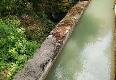
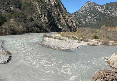
Boucle facile au départ du Broc. La montée dans le vallon de la Sine est très ombragée (givrée en hiver !).Il faut se déplacer un peu pour profiter des points des surplombs Nord et Sud. Très belle vue sur les méandres du Var et la mer,  jusqu'au Cap d'Antibes.
En été inverser le sens pour ne pas descendre le soleil au zénith....

Elevation profile

Photos

Points of interest

Point of interest Le Broc - Le sommet - Photo
ch2slv
LE BROC 
Point of interest Le Broc - Les 2 vallées - Photo
ch2slv
Point of interest Carros - Le bas-Var ! - Photo
ch2slv
CARROS 
Point of interest Carros - Pointe PELOUA - Photo
ch2slv

Positioning

Country:
France
Region :
Provence-Alpes-Côte d'Azur
Department/Province :
Maritime Alps
Municipality :
Le Broc
Location:
Unknown
Start:(UTM)
352691 ; 4852294 (32T) N.

Trails nearby

Trail Walking Aspremont - Vallon OBSCUR aux portes de Nice  - Photo
Walking
clarambre

Walking

Medium
(1)
Aspremont, Provence-Alpes-Côte d'Azur, Maritime Alps, France
5.4 km | 8.5 km-effort
3h 20min
Yes
Trail On foot Bouyon - track - Photo
On foot
domi06

On foot

Medium
(1)
Bouyon, Provence-Alpes-Côte d'Azur, Maritime Alps, France
16 km | 29 km-effort
6h 0min
Yes
Trail On foot Gilette - Tour du mont Lion - Photo
On foot
PRO

On foot

Medium
Gilette, Provence-Alpes-Côte d'Azur, Maritime Alps, France
13.4 km | 25 km-effort
5h 44min
Yes
Trail On foot Carros - Les Balcons de Carros - Photo
On foot
PRO

On foot

Easy
Carros, Provence-Alpes-Côte d'Azur, Maritime Alps, France
4.9 km | 9.1 km-effort
2h 4min
Yes
Trail On foot Bouyon - Gorges de l'Estéron - Photo
On foot
PRO

On foot

Medium
Bouyon, Provence-Alpes-Côte d'Azur, Maritime Alps, France
12 km | 22 km-effort
5h 3min
Yes
Trail Walking Le Broc - mouton d'anou depuis le broc - Photo
Walking
Michel06

Walking

Easy
(1)
Le Broc, Provence-Alpes-Côte d'Azur, Maritime Alps, France
14.3 km | 23 km-effort
5h 13min
Yes
Trail Walking Bonson - Plan du Var-Tourrette du Château  - Photo
Walking
ETMU5496

Walking

Difficult
Bonson, Provence-Alpes-Côte d'Azur, Maritime Alps, France
19.1 km | 35 km-effort
7h 50min
Yes
Trail Walking Le Broc - Le Broc-Bouyon fait - Photo
Walking
ETMU5496

Walking

Difficult
Le Broc, Provence-Alpes-Côte d'Azur, Maritime Alps, France
19.1 km | 31 km-effort
7h 0min
Yes
Trail Walking Le Broc - Le Broc (lac) ; le mouton d'Anou - Photo
Walking
ETMU5496

Walking

Medium
Le Broc, Provence-Alpes-Côte d'Azur, Maritime Alps, France
17 km | 30 km-effort
6h 51min
Yes


Close
My subscriptions